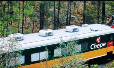
El recorrido mas fabuloso que podemos realizar en ferrocarril, admirando la belleza de la sierra con sus barrancas, acantilados, ríos, y otras maravillas de la naturaleza, es la que nos ofrece el Chepe Chihuahua - Pacifico. Hace mas de cien años, en 1879 Albert K. Owen planeo la construcción de un ferrocarril que partiera desde el vecino Estado de Texas en los Estados Unidos de América hasta la bahía de Topolobampo, el cual cruzaría la Sierra Madre Occidental hasta el Océano Pacifico, pero hubo muchas dificultades sociales, económicas y políticas, por lo que no fue hasta 1961 cuando se termino de construir la ruta.
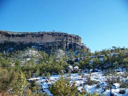
El tramo mas difícil es el que cruza la Sierra Tarahumara en el Estado de Chihuahua, ya que hubo que vencer los obstáculos geográficos propios de una región montan*osa; fue necesario perforar montan*as y construir túneles, ademas de la construcción de imponentes puentes para cruzar las barrancas.
La ruta tiene una extensión de 938 Km; hay 36 puentes, y 96 túneles, de los cuales 72 se localizan en el tramo de San Pedro a Creel. Atraviesa la meseta, después la Sierra Tarahumara, la planicie costera de Sinaloa hasta llegar al puerto de Topolobampo en el Estado de Sinaloa.
El tramo de Topolobampo-San Pedro tiene una longitud de 125 Km. Parte del puerto cruza por el valle de El Fuerte, luego por Los Mochis, pasa por la estación Algodones y la Presa Sufragio, y continua por la cuenca del río Fuerte, hasta llegar a San Pedro.
El tramo San Pedro a Creel, tiene una longitud de 248 Km y cruza las montan*as de la Sierra Tarahumara. A partir de San Pedro, el ferrocarril va ascendiendo desde los 500 metros de altitud hasta los 2100 en Creel, cruzando los dificiles accidentes de la sierra. Despues de San Pedro, cruza La Laguna, San Javier, Boca de Fenix, Boquilla y Lamphar. Este es el limite de Sinaloa y Chihuahua.
Ya en territorio de Chihuahua, el ferrocarril se desvia hacia el can*on del Septentrion, cruzando por la Pera de Chicural, cerca de Temoris, y al llegar a la confluencia del arroyo Cerocachui, hasta llegar al poblado de Cuiteco. Sigue por la región de los Tascales y Areponapuchi, donde se encuentra la imponente Barranca del Cobre; despues atraviesa por el Lazo y los Ojitos, para llegar a Creel.
A partir de Creel se inicia el ultimo tramo de esta gran ruta, cuya longitud total es de 565 Km y recorre zonas a una altitud de 2000 metros. Despues de Creel, el ferrocarril pasa por Bocoyna, Pichachi y La Junta, para despues desfilarse hacia la ciudad de Chihuahua.
El costo del boleto saliendo de ciudad Chihuahua hasta algunas estaciones importantes de la ruta, por Primera Express y Linea Economica:
The ticket out of town to some stations Chihuahua important route for the First Line Express and Economy:
The ticket out of town to some stations Chihuahua important route for the First Line Express and Economy:
Ciudad Chihuahua
- Cuauhtemoc ------------------------------ $ 506.00 -------------- $ 319.00
- Cuauhtemoc ------------------------------ $ 506.00 -------------- $ 319.00
- San Juanito ------------------------------- $ 1,011.00 ------------ $ 637.00
- Creel -------------------------------------- $ 1,129.00 ------------ $ 711.00
- Pitorreal ---------------------------------- $ 1,273.00 ------------ $ 802.00
- Divisadera (Barrancas del Cobre) ---- $ 1,349.00 ------------ $ 850.00
- Posada ------------------------------------ $ 1,365.00 ----------- $ 860.00
- San Rafael -------------------------------- $ 1,403.00 ------------ $ 884.00
- Temoris ----------------------------------- $ 1,673.00 ---------- $ 1,054.00
- Los Mochis ------------------------------- $ 2,482.00 ---------- $ 1,564.00
* Precios actualizados al 14 de Marzo de 2014
* Prices updated at March 14, 2014
The most fabulous trip we can make rail, admiring the beauty of the mountains with ravines, cliffs, rivers, and other wonders of nature, is what we AFREC Cihuahua Chepe - Pacific. Over a hundred an * I, in 1879 Albert K. Owen plans to build a railway that leaves from the Texas State Vesin in the United States of America to the bay of Topolobampo, which cross the Sierra Madre Occidental to the Pacific Ocean, but there were many difficult social, economic and political, for it was not until 1961 when it was finished the route.
The most difficult stretch is the one that crosses the Sierra Tarahumara in the State of Chihuahua, as had to be overcome geographic barriers specific to one region bear mount *, was proved necessary drilling and building mounted * as tunnels, besides the imposing building of bridges to cross the canyon.
The route is an extension of 938 km, there are 36 bridges and 96 tunnels, of which 72 are located on the stretch of San Pedro to Creel. It crosses the plateau, after the Sierra Tarahumara, the coastal plain of Sinaloa to the port of Topolobampo in Sinaloa state.
The stretch of Topolobampo-San Pedro has a length of 125 km from the port crosses the valley of El Fuerte, then for Los Mochis, passing through the station and Dam Algodones Suffrage, and continues for Fort River Basin to to San Pedro.
The San Pedro section Creel, has a length of 248 km and crosses mount * as the Sierra Tarahumara. From San Pedro, the railway ascends from 500 meters up to 2100 in Creel, dificilesaccidentes crossing the mountains. After San Pedro, Cruz La Laguna, San Javier, Boca de Fenix, Nozzle and Lamphear. This is the limit of Sinaloa and Chihuahua.
Already in the territory of Chihuahua, the train was diverted to the dog * on the north, crossing the Chicural Pear near Temoris, and upon reaching the confluence of the stream Cerocachui to reach the town of Cuiteco. Continue along the region of Tlaxcala and Areponapuchi, where the stunning Copper Canyon, after going through the loop and Ojitos, to reach Creel.
From Creel began the last leg of this great route, with a total length of 565 km and covers areas at an altitude of 2000 meters. After Creel, the train passes through Bocoyna, Pichachi and La Junta, to then parade to the city of Chihuahua.


LOS MOCHIS-TOPOLOBAMPO, SINALOA


TEMORIS, CHIHUAHUA


CEROCAHUI


BARRANCAS DEL COBRE


CREEL, CHIHUAHUA